 Citta
Citta Island
 Region
Campania: Artecard 3 - 7 Day or Gold/Lite 365 City Pass
Discover Campania and Naples with a pass to visit 40 cultural sites and public transport (included only in the 3-day pass).
From 27,00 €
 Airport
 Attraction
 Landscape
 Port
Port District
 Street / Square
 Village
The interactive map of Campania featured on this page showcases all the principal tourist destinations and points of interest across the region. You can explore art cities, attractions, beaches, coastal villages and other tourist spots, as well as useful landmarks such as Naples airport and port.
Simply zoom in or pan with your mouse to find the perfect location for your dream holiday! Bookmark this page so you’ll always have this handy online map at your fingertips.
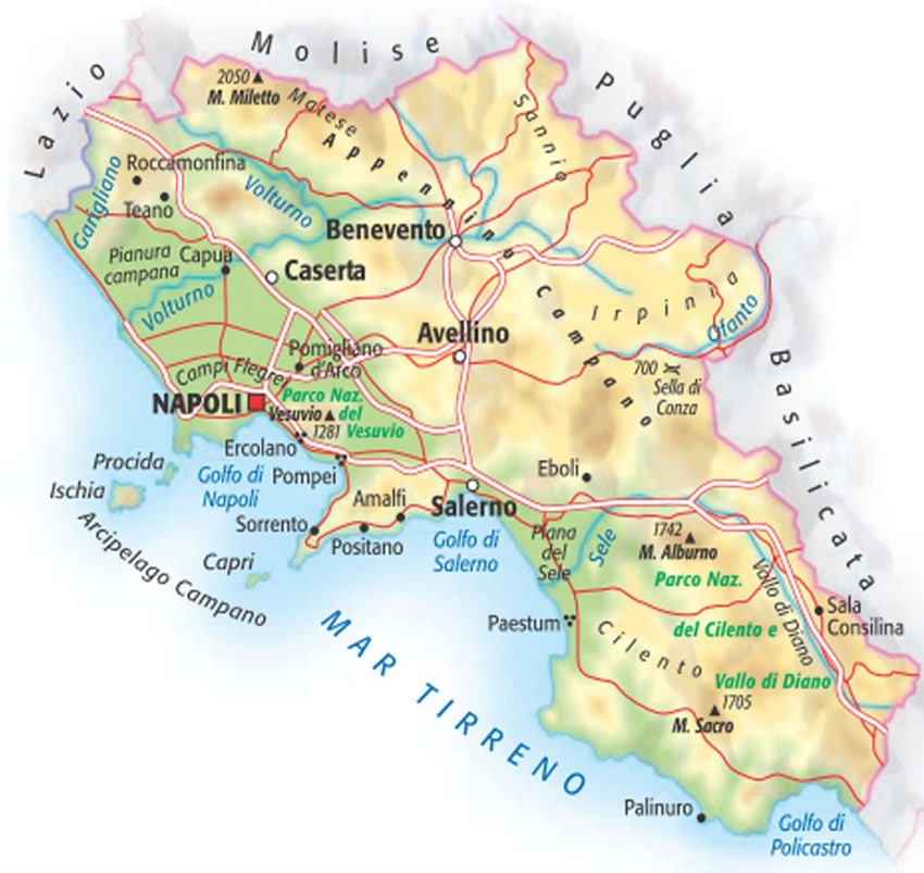
Campania is a region in southern Italy with the highest population count and, nationally speaking, the most densely populated region on the peninsula.
Bordered by the Tyrrhenian Sea to the west and surrounded by the Campanian Apennines to the east, Campania shares borders with Lazio to the north-west, Molise to the north, and with Puglia and Basilicata to the east. Its predominantly hilly terrain is home not only to Vesuvius, one of mainland Europe’s two active volcanoes, but also to important archaeological sites and the spectacular Cilento, Vallo di Diano and Alburni National Park. Along Campania’s coastline you’ll find numerous inlets and bays, and there are four gulfs: the Gulf of Gaeta, the Gulf of Naples, the Gulf of Salerno and the Gulf of Policastro.
Besides the regional capital Naples, there are four provincial capitals: Avellino, Benevento, Caserta and Salerno. From an administrative perspective, Campania also includes the island of Capri and the Phlegraean islands, namely Ischia, Procida, Vivara and Nisida.
City Card allow you to save on public transport and / or on the entrances to the main tourist attractions.
 Hotel
Hotel  Budget accommodations
  Apartments
  Family Hotel
  Luxury Hotel
  Resorts